|
The Summit
Most of my mountaineering has been of 14ers in Colorado, and I'm back
to the 14ers following back problems. Prior to the injury,
I'd been extending my range to glaciated peaks, trying ice climbing and
playing with nuts, quickdraws, runners, and scraping fingernails across
rock face. So my range is extending, not just geographically, but also
in depth of skill. I've yet to buy those too-tight sticky rock shoes,
seems I should be climbing walls in crampons, anyway.
Also, I've got a North Face Assault-22; single wall, four season,
high altitude tent. (Sounds like it will be banned as a federal crime
measure.) This tent performed flawlessly! With high winds, the exterior
of the tent was coated with ice, and yet we stayed warm and dry inside.
The high vents allow condensation to blow out of the tent. This tent is
so windproof, you might want to change your diet before sleeping in it.

In The Works:
Aconcagua 2003
I'm planning on heading south again, and climbing Aconcagua, the highest
peak outside the Himalaya. I'd like to do the Polish Glacier, and
if I can find a few guys with glacier experience, I'll try it. That
might mean a trip to Rainier in 2002 to test out their arrest ability.
Or I may go on a guided trip. I'll post more as I work it out.
Want a taste of Aconcagua? Click here for the Mountain
Zone's Winter ascent.
Colorado 2002: The Long Trip
For July 4th, we are planning on climbing Long's Peak. That
will involve some easy acclimation climbs: Mt. Evans, Mt Bierstadt, the
ridge between, Grays and Torreys.

Past Trips:
Colorado 2001: Sangre de Cristo
We spent Labor Day hiking in the Sangre de Cristo range. We
summitted Mt.
Lindsey, Blanca
Peak, Ellingwood
Point, Challenger
Point, and Humboldt
Peak. I nearly made Kit Carson, and we decided to get better
information before we attempt Little Bear, Crestone Peak, and Crestone
Needle. Click through for stories and photos.
Colorado 2000: San Juans
 After the unfavorable weather conditions we experienced in April of
1999, we returned to the San Juans, but this time in July. We
climbed Handies Peak, Redcloud
Peak, Sunshine Peak, Uncompaghre Peak, Matterhorn
Peak, and Wetterhorn Peak. Click here
for the entire trip report.
After the unfavorable weather conditions we experienced in April of
1999, we returned to the San Juans, but this time in July. We
climbed Handies Peak, Redcloud
Peak, Sunshine Peak, Uncompaghre Peak, Matterhorn
Peak, and Wetterhorn Peak. Click here
for the entire trip report.
Colorado 1999
I climbed in Colorado during April, 1999. I chose the San Juans,
the most remote area in Colorado, and tested a new climbing partner.
We started in Burrows Park,  a
ghost town with two remaining buildings (and one new important one, in
the background.) We camped at 10,400 feet, and started up the
Silver Creek trail until we were somewhat past the South Fork.
From here we snowshoed straight up a steep snow gulley, switched back
and forth between rock and snow, and finally made a windswept ridge.
I summitted Redcloud Peak, 14,034 feet, a
ghost town with two remaining buildings (and one new important one, in
the background.) We camped at 10,400 feet, and started up the
Silver Creek trail until we were somewhat past the South Fork.
From here we snowshoed straight up a steep snow gulley, switched back
and forth between rock and snow, and finally made a windswept ridge.
I summitted Redcloud Peak, 14,034 feet,  and
then got stormed off the mountain. In the photo, behind my ice axe
is Uncompaghre, and the tall peak to the left is Wetterhorn. and
then got stormed off the mountain. In the photo, behind my ice axe
is Uncompaghre, and the tall peak to the left is Wetterhorn.
The next day we attempted Handies Peak, 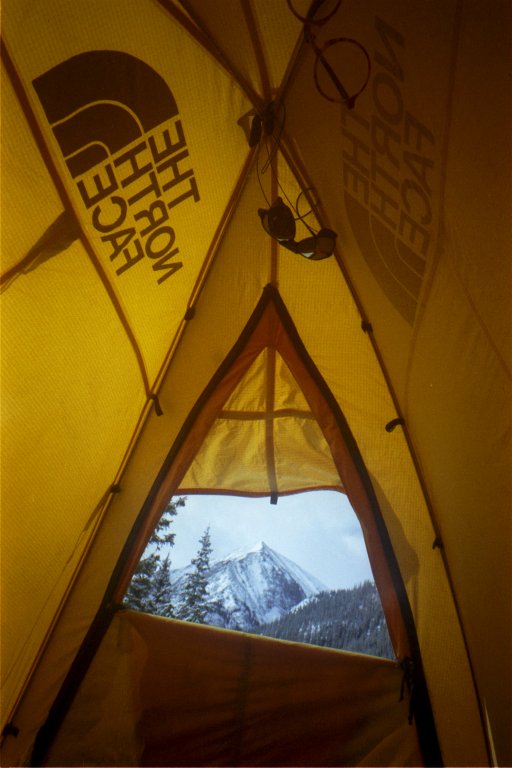 but
the trail register is all we could find. We could not find a
trail, and snow was quite deep, plunging in thigh deep in snowshoes.
So instead we opted for Sunshine Peak, which is right behind Redcloud.
But the storm never let up, and although we camped higher and attempted
to climb, at 13,400 feet we turned back. but
the trail register is all we could find. We could not find a
trail, and snow was quite deep, plunging in thigh deep in snowshoes.
So instead we opted for Sunshine Peak, which is right behind Redcloud.
But the storm never let up, and although we camped higher and attempted
to climb, at 13,400 feet we turned back.  We
got to the car, and found out that a major winter storm system was upon
us, with passes closed, and snow tire and/or chains required on some
mountain roads. We
got to the car, and found out that a major winter storm system was upon
us, with passes closed, and snow tire and/or chains required on some
mountain roads.
We went to Leadville, the storm stayed with us. Finally, we changed
course and decided to do some reverse mountaineering. We went to
Mesa Verde National Park, and from the high point of 8,800 feet, climbed
down a steep ravine to the Gunnison River below, and 6,200 feet.
While this day started sunny, on the trip back up we encountered hail,
and low visibility fog at the top. Storms were upon us again.
New York: Adirondacks High Peaks
In September, '97 we climbed in the Adirondacks in New York. We did a 21
mile loop with full packs, over the top of Mt. Marcy, then Mt. Colden,
and Algonquin Mtn. (We dropped packs and did some pure "peak
bagging" on Wright on the last leg.) No ropes, no crampons, plenty
of oxygen, what a change! Trip highlight: driving off a bear with a
machette to "steal back" my breakfast. Here's a link to some
photos.
 Ecuador: The Volcano Tour Part II
In July, 1997, I climbed three volcanoes in Ecuador: Iliniza Norte,
Cotopaxi, and Pichincha. In January, 1998, I climbed Iliniza Sur.
Click here
for more information on volcanoes of Ecuador.
Iliniza Norte 16,818 feet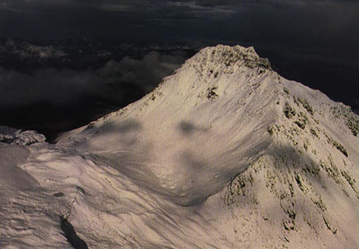
Iliniza Norte and Sur were at one time one volcano, but now are two
distinct peaks. The crater has worn away,
and now all that exists are the insides of the crater that form the
faces of Iliniza Norte and Sur. This photo shows the Norte summit
and face, and the saddle to Sur. The face
of Norte is the inside wall of the original crater. Norte is a rock scramble to the
summit and a good aclimitization climb. We learned that July is the
windy season, and this complicated things somewhat. We were literally in
a cloud, so visibility was limited to under 100 feet. Additionally, the
strong July winds put ice everywhere, disguising cairns from view. On a
well cairned, rock route, we got lost three times. We summitted, took
photos, but the expansive views we'd wanted from a high summit were lost
in the cloud. The next photo is a shot of Norte from the summit of
Iliniza Sur. 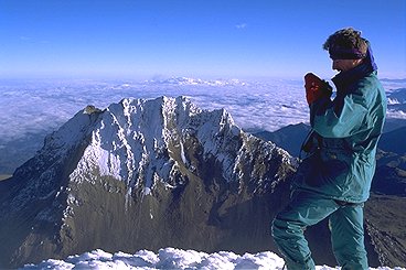
We next attempted to climb Sur, 17,268 feet above sea level, a
technical ice climb, but the fog, high winds and freezing sleet turned
us back.
Iliniza Sur 17,268 feet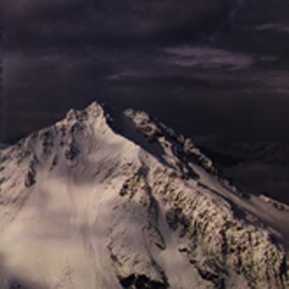
We returned in January 1998, the dry season, and conditions were much
better on Sur than we had experienced in July. Instead of the high winds
and ice, we had balmy temperatures, and no wind. The warmth from el niño
had caused so much ice melt on the glacier that avalanche was a constant
danger.
There are two routes and two summits on Sur. The standard route leads
to a summit around the back of the mountain, the direct route leads
heads straight up the north face (crater wall.) We took the direct
route, an ice climb up a 70 degree route. 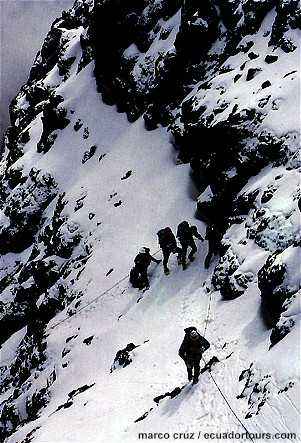 The
70 degree ice kept the route clear, any melting ice quickly dropped to
the saddle, but above the ice wall, where the angles were not so steep,
warm temperatures had melted the ice and it was unstable, like an
italian ice one would eat. Conditions were like slush, with ice tool handles plunging
full length without hitting solid ice. The
70 degree ice kept the route clear, any melting ice quickly dropped to
the saddle, but above the ice wall, where the angles were not so steep,
warm temperatures had melted the ice and it was unstable, like an
italian ice one would eat. Conditions were like slush, with ice tool handles plunging
full length without hitting solid ice.
We climbed the direct route and
reached a rocky band that had to be climbed. Above this band was a
direct ascent to the summit. From here, another summit was visible, and
several footprints led from our summit down the back side of the
mountain. We were unsure whether we summitted on the true summit, or a
subsidiary one. Coming down, we avalanched twice, got caught in rockfall,
and I slid into a crevasse. In the May 1998 Climbing Magazine, we saw
the route and verified that we had indeed made the summit.
Cotopaxi 19,348 feet
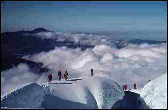 I attempted Cotopaxi on a Sunday in July, 1997. This is not a good
weekend climb. There were over 100 climbers attempting this climb, with
rope teams creating traffic jams on the mountain. I joined a British
rope team and we climbed as far as 18,165 feet before being turned back
by the winds. My clothes, pack and ice axe had over a half inch of ice
covering them. I heard but could not confirm that perhaps eight out of
the hundred climbers summitted that day.
I attempted Cotopaxi on a Sunday in July, 1997. This is not a good
weekend climb. There were over 100 climbers attempting this climb, with
rope teams creating traffic jams on the mountain. I joined a British
rope team and we climbed as far as 18,165 feet before being turned back
by the winds. My clothes, pack and ice axe had over a half inch of ice
covering them. I heard but could not confirm that perhaps eight out of
the hundred climbers summitted that day.
We returned in Janaury 1998, and the weather was wonderful,
visability great, with many successful ascents. Unfortunately, my rope
partner decided to solo the climb, and I was unwilling to climb unroped.
Chimborazo 20,700 feet
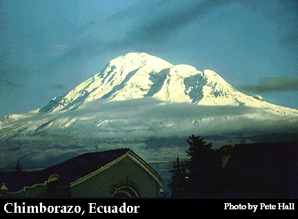 Chimborazo is the highest peak in Ecuador, and higher than anything in
North or Central America.
Due to the bulge at the equator, Chimborazo is father from the center of
the earth than the summit of Everest. (But it's a whole lot easier to
get to!) Due to the high winds we encountered on the other peaks, we
decided to postpone this climb until a different season. Click on
each photo for larger images.
Chimborazo is the highest peak in Ecuador, and higher than anything in
North or Central America.
Due to the bulge at the equator, Chimborazo is father from the center of
the earth than the summit of Everest. (But it's a whole lot easier to
get to!) Due to the high winds we encountered on the other peaks, we
decided to postpone this climb until a different season. Click on
each photo for larger images.
Guagua Pichincha 15,729 feet
Guagua Pichincha is a currently active volcano. The really exciting part
of the climb is supposed to be down into the crater, since its kicking
stuff. However, visibility on this peak was as on the others, and we
summitted in about 40 feet of visibility. Highlight of this climb was
the descent: dropping gear and riding rented mountain bikes down from
14,700 feet down to the Amazon basin at 3,000 feet.
Mexico: The Volcano Tour Part I
In January, 1997, I climbed two volcanoes in Mexico.
Popocatepetl
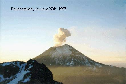 Popocatepetl is perhaps the most well known, since it is currently
active and smoking. Occasionally, it throws rocks and debris from it's
crater. Due to this state, it is also closed to climbers. Popocatepetl,
at 17,733 feet above sea level, is the second highest peak in Mexico.
Here is a photo of Popocatepetl erupting, January 21, 1997. This photo
was taken from the north on Izta, about 7:00 AM, at about 15,000 feet.
Popocatepetl is perhaps the most well known, since it is currently
active and smoking. Occasionally, it throws rocks and debris from it's
crater. Due to this state, it is also closed to climbers. Popocatepetl,
at 17,733 feet above sea level, is the second highest peak in Mexico.
Here is a photo of Popocatepetl erupting, January 21, 1997. This photo
was taken from the north on Izta, about 7:00 AM, at about 15,000 feet.
Iztaccihuatl
Iztaccihuatl is an inactive volcano just to the north of Popocatepetl.
(A portion of Izta is visible in the foreground.) In fact, the trails to
both volcanoes share the same saddle. We climbed Iztaccihuatl as an
acclimatization climb. Izta is the third highest in Mexico, at 17,338
feet. The climb gets to altitude rather quickly, and then is a long hike
above 16,000 feet to the summit. It is not a technical climb, as all of
the ice is on flat icefields, but the length of the climb and the
routefinding difficulties made this climb interesting.
El Pico de Orizaba
 El
Pico de Orizaba is the highest peak in Mexico, and the third highest in
North America. It is a volcano, and rises 18,850 feet above sea level.
After summitting Iztaccihuatl, and taking two much deserved rest days,
we climbed Orizaba on January 31st, 1997. El
Pico de Orizaba is the highest peak in Mexico, and the third highest in
North America. It is a volcano, and rises 18,850 feet above sea level.
After summitting Iztaccihuatl, and taking two much deserved rest days,
we climbed Orizaba on January 31st, 1997.
My climbing partner, and I started out around 2:00 AM, with a team of
three from California. The climb starts from a hut at Piedre Grande,
13,975 feet in altitude. We spent twelve hours there, to acclimatize
somewhat, although the time spent on Izta really made the difference.
From the hut, a short scree climb, followed by a long gradual walk put
us on the lower snowfield, about 15,300 feet. Once on snow, the
routefinding in the dark became much easier. The snowfield is a straight
up climb, leading to the glacier proper at 16,400 feet. Ice and snow
conditions led us to climb unroped; group arrest seemed impossible. From
here, it is straight up. At about 17,000 feet, we met up with the
California team. Shortly thereafter, they turned back, but one of them
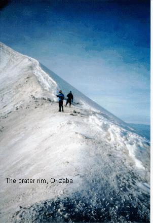
joined us. The next landmark on the glacier is the rim of the crater on
the volcano. This is a photo from the rim of the crater.
From the crater it is a short but steep hike to the windswept top. We
summitted at 8:30 AM. New personal altitude records all around. If we
look cold, we are!
 Orizaba:
The summit! Orizaba:
The summit!
e-mail comments or inquiries to Jim
Richardson
Summits
| Peak |
Altitude |
Location |
Date |
| Humboldt
Peak |
14,064 |
Colorado |
August 2001 |
| Challenger
Point |
14,081 |
Colorado |
August 2001 |
| Ellingwood
Point |
14,042 |
Colorado |
August 2001 |
| Blanca
Peak |
14,345 |
Colorado |
August 2001 |
| Mt.
Lindsey |
14,042 |
Colorado |
August 2001 |
| Handies Peak |
14,048 |
Colorado |
July 2000 |
| Sunshine
Peak |
14,001 |
Colorado |
July 2000 |
| Uncompahgre Peak |
14,309 |
Colorado |
July 2000 |
| Matterhorn
Peak |
13,590 |
Colorado |
July 2000 |
| Wetterhorn Peak |
14,015 |
Colorado |
July 2000 |
| San Luis Peak |
14,014 |
Colorado |
July 2000 |
| Redcloud
Peak |
14,034 |
Colorado |
July 2000 & April 1999 |
| Iliniza Sur |
17,268 |
Eucador |
January 1998 |
| Wright |
4,580 |
New York |
September 1997 |
| Algonquin Mtn. |
5,114 |
New York |
September 1997 |
| Mt. Colden |
4,714 |
New York |
September 1997 |
| Mt Marcy |
5,344 |
New York |
September 1997 |
| Guagua Pichincha |
15,729 |
Ecuador |
July 1997 |
| Iliniza Norte |
16,818 |
Ecuador |
July 1997 |
| Orizaba |
18,850 |
Mexico |
Jan. 1997 |
| Iztaccihuatl |
17,338 |
Mexico |
Jan. 1997 |
| Mt. Evans |
14,264 |
Colorado |
Aug '96, Sept '94, Jul '87 |
| Mt. of the Holy Cross |
14,005 |
Colorado |
Aug. 1996 |
| Mt. Yale |
14,196 |
Colorado |
Aug. 1996 |
| Mt. Columbia |
14,073 |
Colorado |
July 1996 |
| Mt. Harvard |
14,420 |
Colorado |
July 1996 |
| La Plata Peak |
14,336 |
Colorado |
July 1996 |
| Missouri Mt. |
14,067 |
Colorado |
July 1996 |
| Mt. Oxford |
14,153 |
Colorado |
June 1996 |
| Mt. Belford |
14,197 |
Colorado |
June 1996, July 1995 |
| Mt. Tabeguache |
14,155 |
Colorado |
July 1995 |
| Mt. Shavano |
14,229 |
Colorado |
July 1995 |
| Mt. Princeton |
14,197 |
Colorado |
July 1995 |
| Mt. Massive |
14,421 |
Colorado |
July 1995 |
| Huron Peak |
14,005 |
Colorado |
Sept. 1994 |
| Mt. Democrat |
14,000 |
Colorado |
Sept. 1994 |
| Gray's Peak |
14,148 |
Colorado |
Sept. 1994, Sept. 1992 |
| Torreys Peak |
14,267 |
Colorado |
Sept. 1994 |
| Pikes Peak |
14,110 |
Colorado |
Sept. 1994 |
| Mt. Rainier |
14,420 |
Washington |
Aug. 1994 |
| Mt. Sherman |
14,036 |
Colorado |
Oct. 1993 |
| Mt. Elbert |
14,433 |
Colorado |
Oct. 1993 |
| Mt. Quandry Peak |
14,265 |
Colorado |
Oct. 1993 |
| Mt. Lincoln |
14,286 |
Colorado |
Oct. 1993 |
| Mt. Bross |
14,172 |
Colorado |
Oct. 1992 |
| Mt. Bierstadt |
14,060 |
Colorado |
Oct. 1992 |
| Mt. Antero |
14,269 |
Colorado |
Sept. 1991 |
Back to my
Weird Wired World.
Page design by 
High Altitude Webslinger
Last Update 02/14/2002 |